Institute of Environmentology, Research and Education for Sustainability or Sustainable Development, Kazutoshi Fujihira
Sustainable Land Development
Institute of Environmentology >> Sustainable Land Development
Developing unsuitable lands for development leads to various problems, such as biodiversity loss, environmental destruction, climate change, and increased natural disaster risks. In order to avoid such problems and achieve sustainable land development, it is beneficial to define development-restrictive/allowable areas beforehand. Accordingly, based on significant land attributes related to judging development, we have shown how to divide a region or municipality into development-restrictive areas and allowable areas.
How to define development-restrictive/allowable areas
There are three significant land attributes related to judging development, namely (1) biodiversity, (2) natural disaster risk, and (3) topographic gradient (Fig. 1, left). "Biodiversity" is a key area when pursuing environmental preservation and nature conservation. "Natural disaster risk" is connected with an essential requirement, "avoiding natural disaster danger areas." "Topographic gradient" is associated with environmental protection, grading and construction burdens, accessibility, and landscape.

Fig. 1 demonstrates a strategy to divide a region or municipality into development-restrictive areas and development-allowable areas. "Development-restrictive areas" mean sites where land development, including vegetation removal and construction, should be prohibited. Development-restrictive areas are the unions, or amalgamations, of the following sites: (1) areas contributing more to biodiversity, (2) natural disaster high-risk areas, and (3) steep-sloping areas. Meanwhile, "development-allowable areas" are the intersections, or overlaps, of the following: (1) areas contributing less to biodiversity, (2) natural disaster low-risk areas, and (3) gradual-sloping or flat areas.
1.Biodiversity
"Areas contributing more to biodiversity" can be divided into two main categories: (1) identified significant areas for biodiversity, and (2) conservation areas (Fig. 2, left). Currently, there has been a steady increase in the coverage of both identified significant areas and conservation areas. However, further and urgent expansion is necessary (Fig. 2, right).
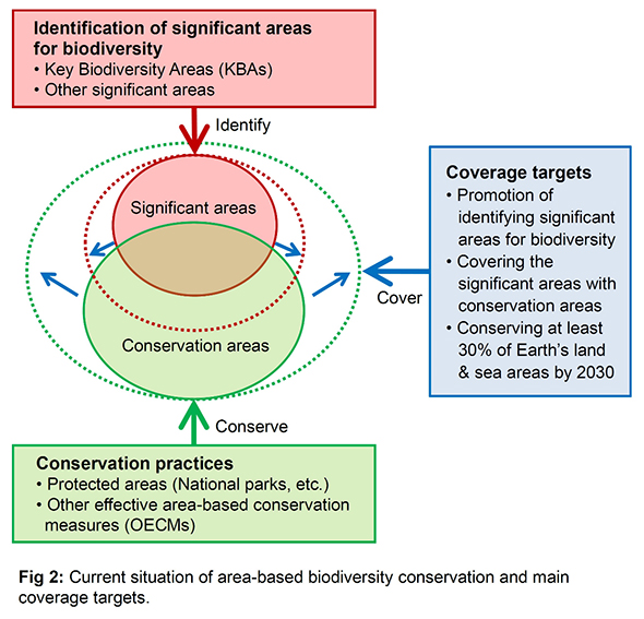
(1)Identified significant areas for biodiversity
The most authorized approach to designate significant areas for biodiversity is the identification of Key Biodiversity Areas (KBAs). KBAs are nationally identified sites that contribute significantly to the global persistence of biodiversity, in terrestrial, freshwater, and marine ecosystems.
(2)Conservation areas (Protected areas, OECMs)
"Protected areas," such as national parks, form the foundation of national biodiversity conservation strategies. In addition to protected areas, "other effective area-based conservation measures (OECMs)" have recently started playing an important role in conservation areas. OECM is a conservation designation for areas that are achieving effective in-situ biodiversity conservation outside of protected areas. At the end of 2022, the UN Convention on Biological Diversity agreed on a target that the world conserves at least 30% of Earth's land and sea areas by 2030 through protected areas or OECMs.
2.Natural disaster risks
"Natural disaster high-risk areas" are sites prone to be exposed to natural hazards. Natural hazards can be divided into two main categories, "climatic hazards," such as floods and droughts, and "tectonic hazards," such as earthquakes and volcanic eruptions. Reducing natural disaster risks requires avoiding areas prone to be exposed to climatic and tectonic hazards.
(1) Climatic hazards
Climatic hazards occur when a region is in extreme weather conditions. For instance, as shown in the central part of Fig. 3, heavy rainfalls and cyclones can cause flooding and landslides. Meanwhile, dryness and heatwaves can trigger droughts and wildfires.
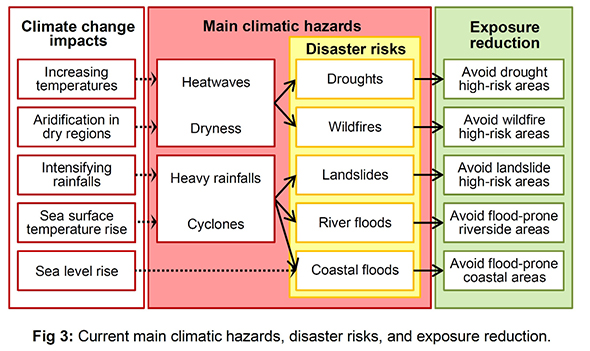
Recently human-induced climate change has been increasing the frequency and intensity of climatic hazards (Fig. 3, left). According to the Intergovernmental Panel on Climate Change (IPCC), heatwaves, droughts, heavy precipitation, and tropical cyclones have strengthened since the 1950s. Continued global warming will further intensify the global water cycle, the severity of wet and dry events, and global monsoon precipitation. Sea levels have also been rising. Increases in cyclone winds and rainfall, and increases in extreme waves, combined with sea level rise, multiply coastal flooding risks.
As shown in the right side of Fig. 3, when considering land use, exposure reduction to climatic hazards is crucial to reduce climatic disaster risks. For instance, efforts to avoid flood-prone areas contribute to reducing flood damage.
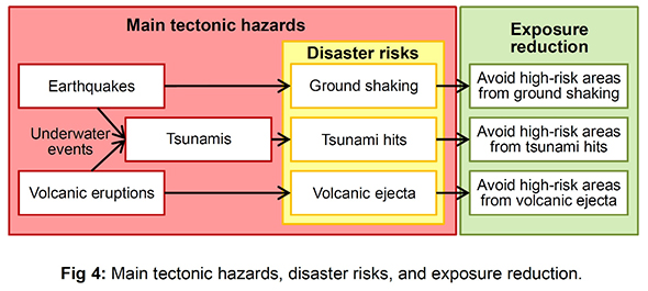
(2) Tectonic hazards
As demonstrated in Fig. 4, two major tectonic hazards are earthquakes and volcanic eruptions. Tsunamis can be generated by underwater earthquakes and volcanic eruptions. Exposure reduction to tectonic hazards primarily requires avoiding high-risk areas from ground shaking, tsunami hits, and volcanic ejecta (Fig. 4, right). For example, it is effective for municipalities to anticipate future tsunami risks and locate facilities on higher ground for safety.
3.Topographic Gradient
Developing "steep-sloping areas" can cause various problems. There is no common definition for "steep slopes." However, many municipalities, especially in North America, define steep slopes as areas with 15% or more gradients. Based on such examples, this study has divided slopes into four categories: (1) gradual (0-10%), (2) moderate (10-15%), (3) steep (15-20%), (4) very steep (20%+) (Fig. 5, left). In addition, examples of slopes with a 10% and 20% gradient are demonstrated on the right side of Fig. 5.
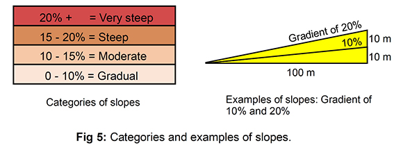
Issues caused by developing sloping areas can be divided into four: (1) adverse effects of removing vegetation, (2) grading and construction burdens, (3) accessibility, and (4) landscape. Removing vegetation on steep slopes can trigger problems, such as soil erosion, landslides, and an increase in downstream runoff. As slopes become steeper, grading and infrastructure provision become more complex and expensive. In addition, incorporating accessibility and universal design also becomes more difficult. Furthermore, steeply sloping areas often offer significant views of hills and valleys; therefore, developing such areas frequently leads to serious disfiguration of the scenic natural beauty.
Generally, steep slopes, namely areas with a slope of 15% or more, should always involve restricting land development. In particular, land development in slope areas over 20% should be strictly limited. Meanwhile, restrictions on developing areas with environmental sensitivity, landscape importance, and walkability-oriented design should start at 10% of a topographic gradient.
4.Integration: Defining development restrictive areas
After collecting spatial data on biodiversity, natural disaster risks, and topographic gradient, of the relevant region or municipality, planners take them in a Geographic Information System (GIS) and draw up GIS map layers. When showing "areas contributing more to biodiversity," it is helpful to divide them into "significant areas" and "conservation areas." As for "natural disaster high-risk areas," the planners create map layers by natural hazard type. Furthermore, in order to demonstrate "steep-sloping areas," they draw up a color-coded map layer according to the classification of gradients.
After completing the necessary map layers, the planners place them on top of one another and integrate the spatial data. In this case, the unions, or amalgamations, of the relevant areas shown on the map layers correspond to development-restrictive areas.
Related publications
Method for Sustainable Land Development: Application to Inagi City, Tokyo
Fujihira, K., 2024, Institute of Environmentology (in Japanese)
Sustainable Land Development: Biodiversity, Natural Disasters, and Topographic Gradient.
Fujihira, K., 2023, IntechOpen, DOI: 10.5772/intechopen.110235